
The Long Island Rail Road (LIRR) map can seem complex at first glance, but understanding its layout will make navigating the system much easier.
Related Post –
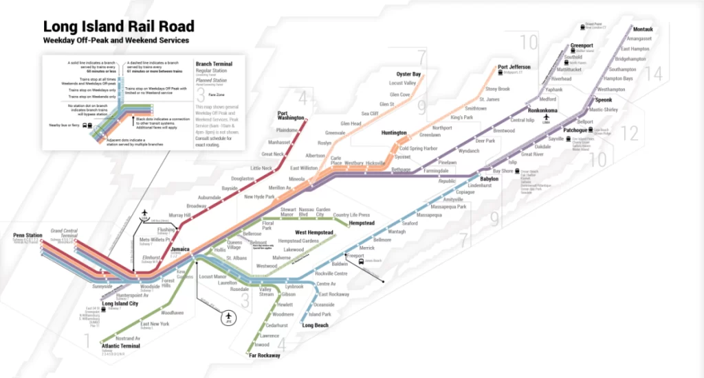
Key Points of the LIRR Train Map
1. Branches and Lines
- Babylon Branch: From Babylon to Penn Station, with stops including Lindenhurst, Copiague, Amityville, and Rockville Centre.
- Huntington Branch: From Huntington to Penn Station, with stops at Cold Spring Harbor, Syosset, and Mineola.
- Ronkonkoma Branch — Runs from Ronkonkoma to Penn Station, with stops like Central Islip, Brentwood, and Hicksville.
- Port Washington Branch: Links Port Washington to Penn Station, with stops such as Great Neck, Manhasset, and Roslyn.
- Long Beach Branch: Travels between Long Beach and Penn Station, with stops including Island Park and Lynbrook.
- Oyster Bay Branch: Runs from Oyster Bay to Jamaica, through Syosset and Hicksville.
- Montauk Branch: From Montauk to Brooklyn, stopping in Amagansett, East Hampton, and Patchogue.
2. Major Stations
- Penn Station: Located in Manhattan, Forest Hills serves as the main terminal for the LIRR with connections to a number of branches.
- Jamaica: A key transfer hub in Queens, serving the AirTrain to JFK Airport, and the E, J, and Z subway lines.
- Hicksville: A major station on the Ronkonkoma, Oyster Bay, and Long Island City branches.
- Mineola: A hub for the Huntington and Ronkonkoma branches, with connections to other local lines.
- Babylon: Terminus for the Babylon branch, with transfers to local and express trains.
3. Connections
- Grand Central Terminal: The new East Side Access project will connect several LIRR branches to Grand Central Terminal starting January 1, 2024.
- Brooklyn: Some Montauk Branch trains extend to Brooklyn, providing connections to various Brooklyn neighborhoods.
4. LIRR Zone Map
- Fare Zones: The MTA LIRR map is divided into fare zones, which determine the price of tickets. Zones are numbered and range from Zone 1 (closest to Manhattan) to Zone 14 (farthest out).
5. Transfer Points
- Switching Stations: Stations like Jamaica and Penn Station allow transfers between different branches and lines.
- Bus Connections: Many LIRR stations have bus connections to local destinations not directly served by the train.
6. Express vs. Local Service
- Express Trains: Certain lines, such as the Babylon and Ronkonkoma branches, have express trains that bypass some stations to provide faster service.
- Local Trains: Local trains stop at all stations along their route.
7. Service Areas
- Residential and Commercial Areas: The Long Island Rail Road Map highlights major residential and commercial areas served by the LIRR, providing access to various neighborhoods and business districts.
8. Travel Times
- Estimated Travel Times: The Map of LIRR often includes travel time indicators between major stations to help passengers plan their journeys.
9. Accessibility
- Accessible Stations: Key stations have accessibility features, including elevators and ramps, for passengers with disabilities.
10. Map Features
- Color Coding: Different branches are color-coded for easy identification.
- Symbols and Icons: The map uses symbols for stations, transfer points, and major landmarks.
The LIRR map is designed to provide a comprehensive overview of the rail network, including branches, major stations, connections, fare zones, and key travel points.
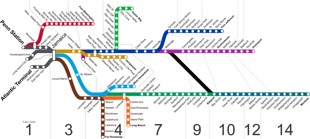
LIRR Stops Map by Branch
Babylon Branch
- Babylon
- Lindenhurst
- Copiague
- Amityville
- Rockville Centre
- Baldwin
- Freeport
- Merrick
- Bellmore
- Wantagh
- Seaford
- Massapequa Park
- Massapequa
- Amityville
- Great Neck
- Hicksville
- Bethpage
- Syosset
- Cold Spring Harbor
- Huntington
Huntington Branch
- Huntington
- Cold Spring Harbor
- Syosset
- Bethpage
- Hicksville
- Great Neck
- Manhasset
- Port Washington
Ronkonkoma Branch
- Ronkonkoma
- Central Islip
- Brentwood
- Hauppauge
- Smithtown
- St. James
- Lake Grove
- Nesconset
- Kings Park
- Commack
- Dix Hills
- Melville
- Hicksville
- Bethpage
- Syosset
- Cold Spring Harbor
- Huntington
Port Washington Branch
- Port Washington
- Manhasset
- Great Neck
- Lake Success
- New Hyde Park
- Floral Park
- Bellerose
- Jamaica
- Woodside
- Penn Station
Long Beach Branch
- Long Beach
- Island Park
- Lynbrook
- East Rockaway
- Oceanside
- Barnum Island
- Hempstead
- Nassau Boulevard
- Malverne
- West Hempstead
- Hempstead Gardens
Oyster Bay Branch
- Oyster Bay
- Syosset
- Hicksville
- Bethpage
- Westbury
- Carle Place
- Mineola
- East Williston
- Roslyn
- Albertson
- Greenvale
Montauk Branch
- Montauk
- Amagansett
- East Hampton
- Sag Harbor
- Bridgehampton
- Water Mill
- Southampton
- Hampton Bays
- Patchogue
- Babylon
These stops cover a wide range of destinations on the LIRR network, from suburban neighborhoods to key transportation hubs.

LIRR Grand Central Map
The new LIRR East Side Access project connects the Long Island Rail Road (LIRR) with Grand Central Terminal in Manhattan. This map outlines the main elements of the LIRR’s increased service to Grand Central, such as stations, tracks, and connections.

Key Features of the LIRR Grand Central Map
1. Grand Central Terminal (GCT)
- Location: Grand Central Terminal is located at 42nd Street and Park Avenue in Midtown Manhattan.
- Main Terminal: The main terminal is the primary area of passenger traffic.
- East Side Access Platform — More new platforms will be needed to accommodate LIRR trains arriving from Long Island. These platforms reside under the current Grand Central Terminal.
2. New LIRR Platforms
- Platform Layout: The new LIRR platforms at Grand Central are designed to handle multiple trains simultaneously, allowing for efficient passenger flow and connections.
- Access Points: Direct access from the platforms to the main terminal concourse, as well as connections to subway, LIRR lines, MTA, and other transit options within Grand Central.
3. Track Configuration
- Track Numbers: The map includes track numbers assigned to LIRR trains arriving at Grand Central. These tracks are numbered to facilitate easy navigation.
- Track Layout: The tracks are positioned to allow for smooth train movements and minimal delays. The layout is designed to integrate with the existing infrastructure at Grand Central.
4. Connections to Other Transit Systems
- Subway Lines: Connections to the Metro-North LIRR Railroad Map, and the New York City subway system, specifically the 4, 5, 6, 7, and S lines, are highlighted. The integration allows for seamless transfers between LIRR and other forms of public transit.
- Buses: Nearby bus connections that serve areas around Grand Central, including routes that connect to different parts of Manhattan and outer boroughs.

5. Access and Amenities
- Entrances and Exits: Key entry and exit points for passengers arriving at and departing from the LIRR platforms at Grand Central.
- Amenities: Information on amenities such as ticketing areas, waiting lounges, restrooms, and food services available within the Grand Central Terminal.
6. Fare Zones
- Zone Information: Details on the fare zones relevant to LIRR trips arriving at Grand Central, which determine ticket prices based on distance from the terminal.
7. Accessibility Features
- Elevators and Ramps: Locations of elevators and ramps that provide access for passengers with disabilities, ensuring compliance with accessibility standards.
- Accessible Platforms: Information on accessible platforms and facilities to assist passengers with mobility challenges.
8. Nearby Landmarks
- Landmarks: Notable landmarks and buildings around Grand Central Terminal, providing context for its location within Manhattan.
The LIRR Grand Central Map illustrates the new infrastructure connecting Long Island Rail Road services to Grand Central Terminal. It includes detailed information on platforms, track layouts, connections to other transit systems, access points, and amenities, all crucial for facilitating smooth and efficient travel.

LIRR Service Map
Here are the key points of the LIRR service map:
- Branch Lines: Shows all major branches: Babylon, Huntington, Ronkonkoma, Port Washington, Long Beach, Oyster Bay, and Montauk.
- Major Stations: Penn Station, Jamaica, Hicksville, Mineola, and Grand Central Terminal
- Track Layout: Displays the layout of tracks, tracks, local & express, and connections between branches
- Fare Zones: Displays how the LIRR network is divided into fare zones, which influence ticket pricing depending on distance from the terminal.
- Express vs. Local Service: Shows whether the trains are express (passing through some stops) or local (stopping at all stations along the route).
- Connections: Information on transfer opportunities to other transit systems, including (e.g., 4, 5, 6, 7) subway lines, Metro-North Railroad, and bus service.
- Multiple Line Stations: Displays stations where multiple LIRR lines meet, like Jamaica and Penn Station.
- Service Area: Show residential and commercial areas served by LIRR trains.
- Accessibility: Label stations that have features for passengers with disabilities, including elevators and ramps.
- Travel Times: Provides estimated travel times between major stations as a planning tool.
- New Developments: Displays any upcoming or recently added lines — new links to Grand Central Terminal, for example.
- Service Frequency: includes frequency of train services, peak, and off-peak.
- Operating Details: Information on operational features such as maintenance facilities and service yards.

LIRR Penn Station Map
Here are the key points of the LIRR Penn Station map:
- Location: Penn Station is located at 34th Street and Seventh Avenue in Manhattan.
- Platforms: This shows the layout of LIRR platforms, generally numbered for different branches.
- Track Layout: Shows tracks for different LIRR lines, including local and express services.
- Ticketing: Ticket vending machine and ticket office location.
- Connections: Subway lines (A, C, E, 1, 2, 3), Amtrak, and New Jersey Transit.
- Amenities: Visit the toilets, eat, and great waiting areas.
- Entrances/Exits: Important passenger entry and exit points.
- Accessibility: Notes elevators and ramps for the disabled
- Service Areas: Shows adjacent residential and commercial sites.
- Information Booths: Where customer service and information desks are located.
- Concourse Layout: Overview of station concourses, including the main and upper-level.

Jamaica LIRR Station Map
Here are the key points of the Jamaica LIRR station map:
- Location: Jamaica Station is situated in Queens, at the intersection of Jamaica Avenue and 164th Street.
- Platforms: Shows the layout of LIRR platforms serving multiple branches, including the Jamaica-bound and Long Island-bound tracks.
- Tracks: Indicates the configuration of tracks for various LIRR lines, including the connection to the AirTrain for JFK Airport.
- Ticketing: Locations for ticket vending machines and ticket offices for purchasing tickets and handling inquiries.
- Connections: Access points to the AirTrain to JFK Airport, as well as connections to subway lines (E, J, Z) and bus services.
- Amenities: Includes information on restrooms, waiting areas, and food services within the station.
- Entrances/Exits: Key entry and exit points for passengers arriving and departing from the station.
- Accessibility: Highlights elevators and ramps for passengers with disabilities, ensuring accessible facilities throughout the station.
- Customer Service: Locations of customer service and information desks for assistance.
- Service Areas: Shows nearby residential and commercial areas served by the station.
- Safety and Security: Includes emergency exits and security features within the station.
LIRR Electrification Map
The LIRR electrification project is a significant infrastructure effort aimed at modernizing the Long Island Rail Road with a more efficient electric train system. Here’s an overview based on current projects and maps:
- Scope of Electrification:
The LIRR aims to electrify branches such as the Port Jefferson Branch and Central Branch. Electrification would eliminate the inconvenience of transferring between diesel and electric trains and would speed up commute times. - Infrastructure Updates:
This project requires major updates, including the installation of:- New substations
- A third rail system
- Platform upgrades
- Bridge, viaduct, and crossing improvements
- New train storage facilities
.
- Funding and Future Plans:
While initial studies are underway, funding remains a key consideration. The project is expected to draw on various New York State budgets and capital investment programs. - OpenRailwayMap Visualization
For an interactive view of the LIRR electrification areas and routes, OpenRailwayMap offers comprehensive railway mapping features.
These efforts aim to enhance commuter experiences, reduce transit times, and improve operational efficiency across Long Island’s train lines.
Q. What does the LIRR map show?
A. The LIRR map gives a visual representation of all train branches, train stations, train zones, and transfer points within Long Island and New York City to aid riders in planning their route.
Q. How are the zones on the LIRR map used?
A. Ticket prices are determined by zones. The more distant the station was from NYC, the greater the zone number and fare.
Q. Can I see all LIRR branches on one map?
A. The official LIRR map does show all 11 branches: Babylon, Hempstead, Long Beach, Montauk, Oyster Bay, Port Jefferson, Port Washington, Ronkonkoma, West Hempstead, City TerminalZone, and Far Rockaway.
Q. Where can I get the official LIRR map?
A. The map is sold in MTA stations, on trains, and online at mta.info.
Q. Does the LIRR map show connections to NYC subways?
A. Yes, the map indicates transfer to NYC subways, buses, and regional transit to travel with ease.